

Cherokee Arch
SUMMARY: A difficult short hike via land to Cherokee Arch. You will pass by Rat Windows #1 and #2 on the way to Cherokee Arch. On the return hike you may choose to visit Mushroom Arch and Rat Windows #3 and #4. Cherokee Arch is a beautiful Arch with a waterfall flowing over it. While it is very close to popular sites such as Princess Arch and Chimney Top Rock the lack of a trail make it a very secluded site. You will absolutely need a topographical map, a GPS and a compass and you will know how to use them.
RATING: Difficult day hike (approximately 2.0 miles total;) This hike uses unmarked trails and many people have trouble navigating the hike. This hike has scrambles/climbs that can be dangerous or deadly. A quality map, compass and deep woods navigating skills are essential for your safety on this hike.

Rat Window #2
BEST TIME OF YEAR TO HIKE: Early spring when flowers are blooming or autumn when you can catch the fall colors. This hike is also nice in winter as it is easier to find the “trail” without all of the growth. The USDA Forest Office is located in Winchester, Kentucky about an hour from Red River Gorge. For up to date information either stop in the Ranger District Office, visit their website or telephone: (859) 745-3100.

Rat WIndow #1
AMOUNT OF TIME NEEDED:Allow a half of a day (4-6 hours) to enjoy this hike. The scenery is spectacular, the geology is interesting; and, the arch is a perfect place to have lunch and explore. Pack a lunch and enjoy the adventure!
DIRECTIONS TO TRAILHEAD:
- From rest area at exit #33 off of the Mountain State Parkway Turn left, and return to the Mountain State Park – West (8 miles)
- Take Exit 40 for for KY-15/KY-715 toward Beattyville. (0.3 miles)
- Turn right at KY-15 N/KY-715 N. (0.7 miles)
- Take the 1st right onto KY-715 N. (2.2 miles)
- Turn left Chimney Rock Road. (3.5 miles)
- Park in Chimney Rock parking area at the end of road.

Cherokee Arch
DETAILS:
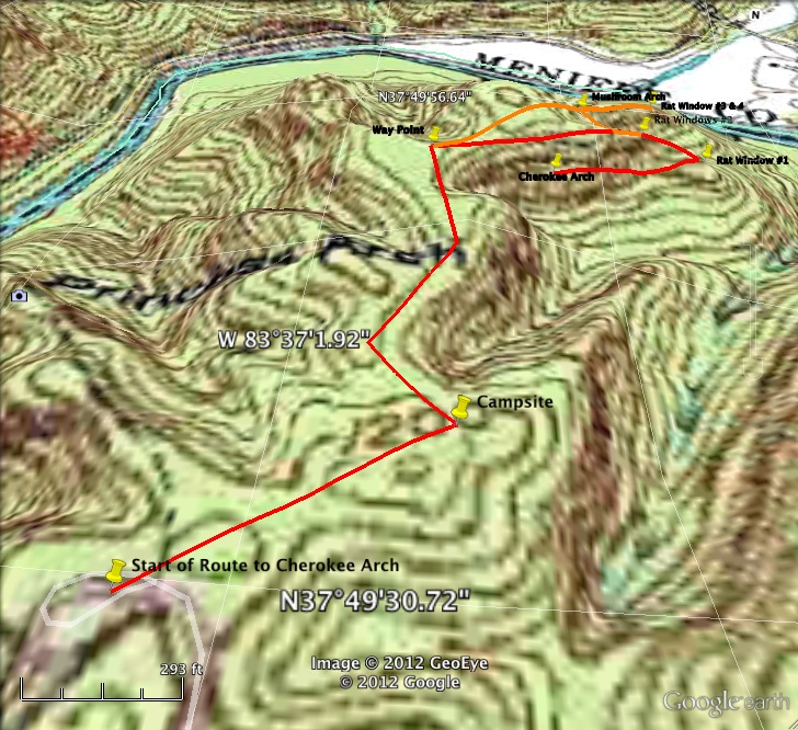
- From the parking area find the start to the trail to Princess Arch, just to the right of the trail to Princess Arch are two posts at the start of an unofficial trail. This is the start of the trail to Cherokee Arch.
- Follow the unmarked trail to the last campsite going straight out the ridge you are on. For those using GPS the coordinates of the last campsite are below. (0.2 miles)
- Turn left (it is easy to miss the turn) onto another unmarked trail and make your way towards the waypoints indicated below. (0.2 miles) (the unmarked trail is sometimes impossible to find.) For those without a GPS, imagine you have been walking up the base of the letter “Y” The trail splits with a ravine in the middle and you are heading out the left branch of the “Y”. Your goal is to follow the right edge of the left branch of the “Y” as close as possible. You are going all the way to the top right corner of the left branch of the “Y” where you will eventually find Rat Window #1.
-

Mushroom Arch
From the way point continue in the same direction to Rat Window #2, it is easy to go to far to the left and veer off the trail. (0.2 miles)
- Arrive at Rat Window #2 (you will have to go below to see it), and continue out the ridge to Rat Window #1. (200 feet)
- Arrive at Rat Window #1, and make a hard right turn and go down to the valley below. Make another right turn on the valley floor (you will have made a u-turn) and backtrack below the ridge line you came out to Cherokee Arch. (0.25 miles) When you were at the waypoint you were close to Cherokee Arch, but it is necessary to go out the ridge line to Rat Window #1, descend, and then backtrack to Cherokee Arch. Cherokee Arch is NOT accessible from above.
- Back track to Rat Window #1. (0.25 miles) From here you can look NW and see the ridge with Rat Windows #3 and #4 a little below you. Mushroom Arch is on the same ridge, but much closer to where the ridge you are on meets up with the other ridge.
-

Start of Hike to Cherokee Arch
Continue back tracking to Rat Window #2 (200 feet)
- For those wishing to see Mushroom Arch and Rat Windows #3 and #4, continue on up the ridge you are on until you can turn right and go across to the other ridge. (0.2 miles) Do NOT descend to the valley to get across to the other ridge. Cross to the other ridge and head all the way out to the end to find Rat Windows #3 and #4. For those not wishing to see the additional arches backtrack the way you came via the way point and campsite.
- Skip mushroom arch, and arrive above Rat Windows #3 and #4. I have not descended below to see the windows because I did not have the proper equipment, and I do not suggest descending this dangerous cliff line without equipment and training. These are the coordinates of the ridge, and it is also a wonderful view of the Gladie area. Backtrack up the left side of the ridge and you will find Mushroom arch tucked away in a corner. It is much easier to find Mushroom Arch while backtracking. (0.2 miles)
- Return back to the way point. (0.2 miles)
- Return to the campsite. (0.2 miles)
- Turn right and return to the parking area. (0.2 miles)


GPS Coordinates of start of hike to Cherokee Arch 37, 49′ 30.26 N 83, 37′ 04.78 W GPS Coordinates of campsite 37, 49′ 34.87 N 83, 36′ 56.12 W GPS Coordinates of waypoint #1 37, 49′ 37 N 83, 36′ 59 W GPS Coordinates of waypoint #2 37, 49′ 48.3 N 83, 36′ 57.47 W GPS Coordinates of Rat Windows #2 37, 49′ 51.6 N 83, 36′ 47.4 W GPS Coordinates of Rat Windows #1 37, 49′ 50.8 N 83, 36′ 43.3 W GPS Coordinates of Cherokee Arch 37, 49′ 47.8 N 83, 36′ 52.3 W GPS Coordinates of Mushroom Arch 37, 49′ 53.1 N 83, 36′ 49.6 W GPS Coordinates of Rat Windows #3 & #4 37, 49′ 54.3 N 83, 36′ 47.5 W
