
SUMMARY: An easy hike to beautiful overlooks. This hike is also know as Tarr Ridge, I prefer to use the name Jennifer’s Overlook. I did not name this hike and sadly someone removed the signs that used to mark this hike and made navigation easier. If you have some time, investigate why it is called Jennifer’s Trail, I cannot reveal all of the Gorge’s secrets here. The hike follows the top of a ridge line, and at different points you can stroll out and enjoy the vistas. I have highlighted four of the best vistas, but there are other vistas if you want to go find them. The easy stroll to the first two vistas places this hike on my list of favorites. Use extreme caution while enjoying this hike, especially if you decide to scramble up to either of the last two ridges to the last two vistas!
RATING: Moderate Hike (about 4.0 miles.) The hiking is easy if you only visit the first two vistas, but there is a difficult scramble to get to each of the later two vistas that may require a rope. This hike uses unmarked trails and many people have trouble navigating the hike. This hike has scrambles/climbs that can be dangerous or deadly. A quality map, compass and deep woods navigating skills are essential for your safety on this hike.

Jennifer’s Overlook (Signs have been Removed)
BEST TIME OF YEAR TO HIKE: Early spring when flowers are blooming or autumn when you can catch the fall colors. The USDA Forest Office is located in Winchester, Kentucky about an hour from Red River Gorge. For up to date information either stop in the Ranger District Office, visit their website or telephone: (859) 745-3100
AMOUNT OF TIME NEEDED: Allow a half of a day (2-4 hours) to enjoy this hike.
DIRECTIONS TO TRAILHEAD:
- From rest area at exit #33 off of the Mountain State Parkway Turn left, on Hwy 11 (0.1 miles)
- Turn left onto Hwy 15 (1.5 miles)
- Turn right on Hwy 77 (5.1 miles)
- Turn left on Hwy 77 (1.5 miles)
- Park in a pull off on the right side at the top of the hill. There is a large forest service sign.
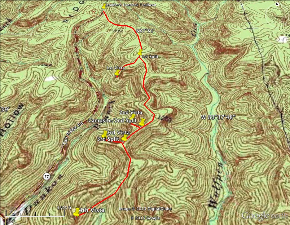
DETAILS :
- The trail heads south from the right side of the parking area and back tracks on a ridge above the road you just ascended. Do NOT cross the road. There are several false trails that lead to camping areas, but the actual trail is very clear once you are on it. There are several splits on this trail, when I refer to a split being the 1st or 2nd it is the 1st or 2nd split I documented, there are many splits I did not include in the trail description. For this reason, GPS will help. (0.56 miles)
- Turn right at the first split and head out to the 1st vista. (0.19 miles)
- Enjoy the 1st vista and return to the main trail. (0.19 miles)
- Turn right and continue heading south on the main trail. (0.54 miles)
- Turn right at the second split and head out to the 2nd vista. (0.1 miles)
- Enjoy the 2nd vista and return to the main trail. (0.1 miles)
- Turn right and continue heading south on the main trail. (0.1 miles)
- Turn right at the 3rd split and head out to the 3rd vista. (0.1 miles) To get to this vista it will require a scramble using a rope. If you are uncomfortable or not prepared turn around and enjoy the earlier vistas.
- Enjoy the 3rd vista and return to the main trail. (0.1 miles)
- Turn right and continue heading south on the main trail arriving at the 4th vista. (0.41 miles) To get to this vista it will require a scramble using a rope. If you are uncomfortable or not prepared turn around and enjoy the earlier vistas.
- Return to the trailhead via the main trail. (1.61 miles)
 GPS Coordinates of unmarked trail starting hike to Jennifer’s Overlook
37, 51′ 10N
83, 38′ 31 W
GPS Coordinates of first split in unmarked trail to Jennifer’s Overlook
37, 50′ 47 N
83, 38′ 15 W
GPS Coordinates of unmarked trail starting hike to Jennifer’s Overlook
37, 51′ 10N
83, 38′ 31 W
GPS Coordinates of first split in unmarked trail to Jennifer’s Overlook
37, 50′ 47 N
83, 38′ 15 W GPS Coordinates of first vista on Jennifer’s Overlook 37, 50′ 40 N 83, 38′ 23 W
GPS Coordinates of campsite and second split in unmarked trail to Jennifer’s Overlook 37, 50′ 23 N 83, 38′ 14 W
GPS Coordinates of second vista on Jennifer’s Overlook 37, 50′ 25 N 83, 38′ 17 W
GPS Coordinates of third split in unmarked trail to Jennifer’s Overlook 37, 50′ 19 N 83, 38′ 19 W GPS Coordinates of third vista on Jennifer’s Overlook 37, 50′ 20 N 83, 38′ 25 W
GPS Coordinates of fourth vista on Jennifer’s Overlook 37, 50′ 03 N 83, 38′ 30 W
