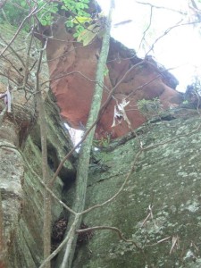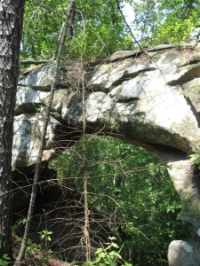
SUMMARY: This hike takes visitors out on Pinch-Em Tight Ridge a ridge with spectacular views and a great location for camping while backpacking. We frequently just come out here for the awesome views and skip the arches.
RATING: Difficult day hike (approximately 5.4 miles total;) very spectacular scenery; basic services at the trailhead. This hike follows mostly marked trails and unmarked trails that are fairly easy to navigate. However, the last section (about 0.8 mile) of the hike is on unmarked and on non existent trails that require good navigational skills and tough off trail hiking. This hike uses unmarked trails and many people have trouble navigating the hike. A portion of this hike does NOT have any trail. This hike has scrambles/climbs that can be dangerous or deadly. A quality map, compass and deep woods navigating skills are essential for your safety on this hike.
BEST TIME OF YEAR TO HIKE:Early spring when flowers are blooming or autumn when you can catch the fall colors. The USDA Forest Office is located in Winchester, Kentucky about an hour from Red River Gorge. For up to date information either stop in the Ranger District Office, visit their website or telephone: (859) 745-3100
AMOUNT OF TIME NEEDED: Allow a full day (4-8 hours) to enjoy this hike. The scenery is spectacular, the geology is interesting; and, the arch itself is a perfect place to have lunch and explore. Bring water (there is none on the route,) pack a lunch and enjoy the adventure!

DIRECTIONS TO TRAILHEAD:
- From rest area at exit #33 off of the Mountain State Parkway Turn left, and go to end of road (.3 miles)
- Turn Right onto KY 15 (3.3 miles)
- Turn Left onto Tunnel Ridge Road (0.9 miles)
- Park at Gray’s Arch Picnic Area (on right)
DETAILS :
- From the Gray’s Arch picnic Area, go back up Tunnel Ridge Road (0.1 miles)
- Turn Left onto Trail #223 Pinch ’em Tight Trail (1.7 miles)
- Turn Left onto Trail #221 Rough Trail (0.1 miles)
- Turn right on unmarked trail leading out Pinch-Em Tight Ridge. (0.5 miles)
 You will arrive at a large campsite after passing a couple of smaller campsites. Turn right here and go to Ledford arch and a beautiful overlook. 100′ before walking out on the overlook turn right again on a non existent trail and arrive to Ledford arch. Make sure you return and check out the overlook. (0.3 miles)
- Arrive at Ledford arches. You will arrive at the smaller one first and immediately after the larger one. It is easy to get mixed up and end up way below the arch. If that happens it will help you to orient and finally get to the arch. As you go out the final out cropping that the arch is on, you must scramble down about 5′ a small ledge on your left side that will allow you to get out to the arches. Happy Hunting!
- Return via the non existent trail until to arrive at the unmarked trail heading out Pinch-Em tight ridge. (0.3 miles)
- Turn left on unmarked trail that lead out to Pinch-Em tight ridge. (0.5 miles)
- Turn Left onto Trail #221 Rough Trail (0.5 miles)
- Turn Right onto Trail #223 Pinch ’em Tight Trail (1.7 miles)
- Turn Right on Tunnel Ridge Road (0.1 miles)
- Arrive at Gray’s Arch Picnic Area
BONUS : If you cannot find these arches, just getting out to the view point on Pinch-Em Tight Ridge is well worth the hike, and there is also some great camping in the area.
GPS Coordinates of intersection of Trail #221 Rough Trail and unmarked Trail 37°48’41.8″N 83°38’12.19″W GPS Coordinates of waypoint on unmarked Trail 37°48’46.61″N 83°38’12.35″W GPS Coordinates of campsite on unmarked Trail 37°49’0.09″N 83°37’55.21″W GPS Coordinates of Ledford Arch 37°48’50.9″N 83°37’33.9″W GPS Coordinates of viewpoint past campsite (tiny detour on unmarked trail) 37°48’58.94″N 83°37’38.73″W
